

PATHWAY LAND SURVEYS, LLC
QUALITY BY ANY MEASURE
SERVICES

Boundary and ALTA Surveys
Boundary and Legal Surveys are used to depict ownership and rights of usage by utilizing surveyed monuments, record documents and other evidence.
Including but not limited to:
-
Legal descriptions and accompanying exhibit drawings for right of way or easement acquisition and transfers.
-
Lot Surveys
-
Boundary Surveys
-
Platting and Subdivisions
-
Record of Surveys
-
Maps of Dedication
-
ALTA / ASCM Land Title Surveys
-
Right of Way Strip Maps

Topographic and Design Surveys
Surveys are performed to collect data for the spatial relationship of natural and man-made features to a particular datum from which a three-dimensional map may be prepared. Including but not limited to:
-
Control for Aerial Mapping
-
Design Surveys
-
Digital Terrain Models
-
Drainage Studies
-
Site Surveys
-
Structural Monitoring and Deformation Surveys
-
Transportation and Utility Route Surveys
-
Utility Inventory or Studies
-
Volumetric Surveys
-
Monitoring Well Surveys
Construction Survey Services
Construction Staking provides Contractors and Owners with the correct location and elevation of each project element.
Including but not limited to:
-
Pre-Constructions surveys to verify project control, existing conditions and utilities
-
Establishment of horizontal and vertical control for Contractor and Owner’s use
-
Clearing or Project Limits
-
Mass Grading
-
Water and Sewer Facilities and Systems Layout
-
Storm Drain, Channel and Box Culvert Layout
-
Dry Utility Layout for Power, Traffic Signals, Gas and Communications
-
Buildings and Structures
-
Bridge Construction
-
Curb, Gutter, Sidewalk and Concrete Layout
-
Subgrade, ABC and Paving Grading
-
Roadway and Airfield Striping, Pavement Marking and Signage Layout
-
Monuments new or restored
-
Volume calculations
-
Anchor Bolt layout and As-builts for Steel Erection
-
As-builts per the controlling jurisdiction
-
Finish Floor, Pad and Retention along with Setback and Height Certifications

ABOUT
At Pathway Land Surveys we believe Surveying is the foundation of a successful project. Understanding the boundaries, legal encumbrances and unique topographic conditions of a site form the basis from which owners, designers and contractors will depend on to provide the most cost-effective, efficient and ultimately successful project. That is why our work isn’t just about measurements; it’s about understanding client expectations and exceeding them.
Owner / Manager Ed Balliet is a Registered Arizona Land Surveyor and Certified Federal Surveyor with over 30 years of Land Survey experience.
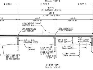
PROJECTS

Grading rail
CONTACT
Inquiries
For any inquiries, questions or commendations, please call: 480-294-7481 or fill out the following form
Address
Employment
To apply for a job with Pathway Land Surveys, please send your resume to: info@pathway-ls.com